Barbados flag

GILGAMSH — Cargo · IMO 9558452

BBUnder way using engine
World map showing the last known position of GILGAMSH at 19° 11.981' N, 38° 56.933' E
NSEW
Export GILGAMSH's past journey as a videoMP4 in 16:9, 9:16 or 1:1 · up to 90 days
Current PositionNo recent signal

GILGAMSH has not broadcast an AIS position for 12 days. Its most recent report placed it in the Red Sea, at 19.1997° N, 38.9489° E, on 26 Oct 2026, 19:03 UTC. It was sailing from JEDDAH to PORT SUDAN.

Updated 12 days using terrestrial data
Live Satellite · latest position

See where GILGAMSH is now

1 credit fetches 1 satellite position.

Terrestrial data is 12 days old. Use a satellite credit for the latest position, updated minutes ago — satellites track vessels in the deep sea.

Get satellite data
Auto top-up

On for your next purchase

Turn off to prevent future automatic charges.

Under way using engine
Current Navigational Status
1.3 kn
Speed
13.0°
/ 42°
Course / Heading
5 m
Static Draught
7.2 m
Current Draught

Voyage Tracker

Saudi Arabia flag
JEDDAHSAJED
ATD
12:04 UTCOct 22, 2026
ETA
10:00 UTCOct 28, 2026
GILGAMSH

GILGAMSH

Identity

Cargo
Type
Barbados flagBB
Flag
9558452
IMO Number
314678000
MMSI
8PDO2
Call Sign

Specifications

132 m × 18 m
Length × Breadth
2009-01-01
Year Built
8,500 t
Deadweight
6,881 t
Gross Tonnage
N/A
Engine Power
HONGSHENG SHIPBUILDING - LINHAI, CHINA
Builder
LLOYD'S SHIPPING REGISTER
Class Society
Live tracking · 50,000+ mariners

Track GILGAMSH live on MarineRadar

Real-time AIS positions, voyage history, and arrival alerts for GILGAMSH — straight from your phone.

Live AIS positionsVoyage historyArrival alerts
Get the App

4.6 ★ · 18,000 reviews

About GILGAMSH

Identity · Ownership · Class · Route

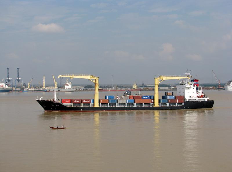
GILGAMSH — Cargo

Built in 2009, with a gross tonnage of 6,881 GT, and a dead weight of 8,500 tonnes, GILGAMSH is a cargo registered under the Barbados flag. The vessel is owned by MYANMA FIVE STAR LINE - YANGON, MYANMAR, built by HONGSHENG SHIPBUILDING - LINHAI, CHINA.

GILGAMSH route and voyage history

GILGAMSH is currently on a voyage from JEDDAH to PORT SUDAN with an estimated arrival on 2026-10-28T10:00:00Z. The live route and current course of GILGAMSH are shown on the bridge map above, updated whenever the vessel is in range of a coastal AIS receiver or a satellite pass.

Vessel class and identifiers

GILGAMSH is classed by LLOYD'S SHIPPING REGISTER, which inspects the vessel against its safety and structural rules. Vessels in the same class as GILGAMSH can be seen in the Similar Vessels section above or in the full cargo fleet at /vessel-type/cargo.

  • MMSI: 314678000
  • IMO: 9558452
  • Call sign: 8PDO2
  • Vessel type: Cargo
  • Flag state: Barbados

Frequently Asked Questions

Where is GILGAMSH right now?

+

GILGAMSH has not broadcast an AIS position for 12 days. The most recent broadcast placed it in the Red Sea, on 26 Oct 2026, 19:03 UTC. It was sailing from JEDDAH to PORT SUDAN. Vessels stop appearing on terrestrial AIS when they move beyond receiver range, so a gap does not necessarily mean the vessel is inactive.

What are the identifiers for GILGAMSH?

+

GILGAMSH broadcasts MMSI 314678000 and is registered as IMO 9558452, with call sign 8PDO2. The MMSI is the radio identifier used by AIS; the IMO number stays with the ship for life and does not change with re-flagging or sale.

What type of ship is GILGAMSH?

+

GILGAMSH is classified as a cargo vessel registered under the BB flag. The vessel-type classification is derived from the AIS Type field broadcast by the ship's transponder; full cargo fleet at /vessel-type/cargo and full BB flag list at /flag/bb.

How can I see the live position of GILGAMSH?

+

MarineRadar shows the latest AIS broadcast from GILGAMSH above, with current position, course, speed, and navigation status. Tap "View on map" to centre the live tracker on the vessel and watch its movement update in real time. The same data is available offline-friendly in the iOS and Android apps.

How often is GILGAMSH's position updated?

+

AIS transponders broadcast position every 2 seconds when underway at high speed and up to every 3 minutes at anchor. The position you see refreshes whenever the ship is in range of a coastal AIS receiver or a satellite pass — typically seconds in coastal waters and minutes offshore.

What class is GILGAMSH?

+

GILGAMSH is classed by LLOYD'S SHIPPING REGISTER, the classification society responsible for inspecting the vessel against safety, structural and operational rules. As a cargo, GILGAMSH sits in the same design class as the other cargos listed in the Similar Vessels section of the vessel page, or in the full cargo directory at /vessel-type/cargo. GILGAMSH has a gross tonnage of 6,881 GT.

GILGAMSH — Key Facts

MMSI
314678000
IMO number
9558452
Call sign
8PDO2
Vessel type
Cargo
Flag state
BB
Navigation status
Under way using engine
Current speed
1.3 knots
Course over ground
13.0°
Heading
42°
Last known position
19.1997°, 38.9489°
Destination
PORT SUDAN
ETA
2026-10-28T10:00:00Z
Departure port
JEDDAH
Actual time of departure
2026-10-22T12:04:00Z
Current draught
7.2 m
Maximum static draught
5 m
Year built
2009-01-01
Gross tonnage
6881
Dead weight
8500 t
AIS last updated
2026-10-26T19:03:00Z