

Track any
Vessel, Anywhere!
Stay ahead of the waves!


75,000+
Vessels
120+
Countries
7,000+
Ports
8000+
Light houses
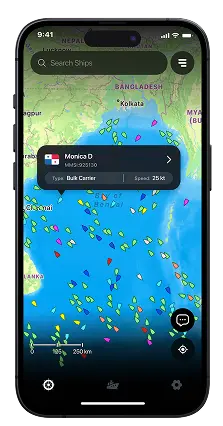
Every Vessel, Every Move
Tap into live ship data — names, types, routes, destinations, and full history at your fingertips.
VLORA
Albania
ATD
1:37 PM
7 Jun, 2025
MARJ
Egypt
ETA
9:45 PM
21 Jul, 2025

Monica D
CALL SIGN
PANAMA
FLAG
Offline Maps
Stay on course even without internet

AccuracyNever miss a vessel, even
in remote seas


Past route playbacks
View your ship's full path, port to port

Vlora
Catanzaro
Malta
Marj


7759 NM, 246°
FOCAL HEIGHT
FLASH INTERVAL
COLOUR
LIGHT RANGE
NUMBER OF FLASHES
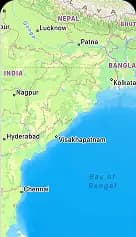

7759 NM, 246°


Monica D
Bulk Carrier
Asia Evergreen
Tanker
in one view


Speed
Course
Arrival
Departure
What our users are saying
Hear from our marine enthusiasts about how MarineRadar has enhanced their navigation and delivered real-time insights at sea.

Takashi Murakami

Heric da paz Buque

Adrian Alfredo

Sagarika G S

Gervásio Campos Man Joja

Faizan Tahir
Join my newsletter
Receive fresh articles straight in your inbox, every Friday morning. I also share interesting finds from the internet!
Weekly newsletter only. No spam, unsubscribe at any time.

Frequently asked questions
Quick guidance to understand how our tracking and plans work.
Couldn't find your answer
Talk to us
Maritime professionals already using
MarineRadar

Monica D
MMSi:925130