Malta flag

HILDE ACargo - Hazard X (Major) · IMO 9305908

MTMoored
World map showing the last known position of HILDE A at 33° 36.500' N, 7° 35.721' W
NSEW

Latitude / Longitude

33° 36.500' N
7° 35.721' W

Show in Map
Updated 1 day ago using terrestrial data
Live Satellite · every 5 min

Need more up-to-date positions?

This page shows terrestrial AIS. Download the app for live satellite tracking, refreshed every 5 minutes worldwide.

Get App
Moored
Current Navigational Status
0.0 kn
Speed
120.6°
/ 332°
Course / Heading
9.7 m
Static Draught
10 m
Current Draught
ATD
May 14, 2026, 11:14 UTC
ETA
May 22, 2026, 12:56 UTC
From
GENOVA
To
CASABLANCA

Voyage Tracker

Italy flag
GENOVAITGOA
ATD
11:14 UTCMay 14, 2026
ETA
12:56 UTCMay 22, 2026
HILDE A

HILDE A

Identity

Cargo - Hazard X (Major)
Type
Malta flagMT
Flag
9305908
IMO Number
215426000
MMSI
9HA2043
Call Sign

Specifications

184 m × 24 m
Length × Breadth
2005-01-01
Year Built
22,049 t
Deadweight
17,665 t
Gross Tonnage
N/A
Engine Power
PS WERFTEN WOLGAST - WOLGAST, GERMANY
Builder
GERMANISCHER LLOYD
Class Society
Live tracking · 50,000+ mariners

Track HILDE A live on MarineRadar

Real-time AIS positions, voyage history, and arrival alerts for HILDE A — straight from your phone.

Live AIS positionsVoyage historyArrival alerts
Get the App

4.8 ★ · 3,200 reviews on the App Store.

Dive into the fleet, port, and flag state that HILDE A is part of.
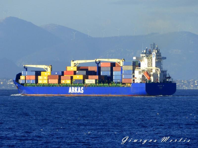
Flag State
All MT-flagged vessels
Browse every ship currently registered under the MT flag, with live AIS positions.
Vessel Type
Browse all Cargo - Hazard X (Major)s
See the global fleet of cargo - hazard x (major)s tracked on MarineRadar with live AIS data.
Departure Port
Port of GENOVA
Port traffic, arrivals and live vessel positions for GENOVA (ITGOA).
Destination Port
Port of CASABLANCA
Arrivals, berth specifications, and live vessel traffic for CASABLANCA (MACAS).

About HILDE A

Identity · Ownership · Class · Route

HILDE A — Cargo - Hazard X (Major)

Built in 2005, with a gross tonnage of 17,665 GT, and a dead weight of 22,049 tonnes, HILDE A is a cargo - hazard x (major) registered under the Malta flag. The vessel is owned by ARKAS SHIPPING & TRANSPORT - IZMIR, TURKEY, built by PS WERFTEN WOLGAST - WOLGAST, GERMANY.

HILDE A route and voyage history

HILDE A is currently on a voyage from GENOVA to CASABLANCA with an estimated arrival on 2026-05-22T12:56:00Z. The live route and current course of HILDE A are shown on the bridge map above, updated whenever the vessel is in range of a coastal AIS receiver or a satellite pass. View HILDE A's full route replay to see voyage history, course changes, and port-by-port movement.

Vessel class and identifiers

HILDE A is classed by GERMANISCHER LLOYD, which inspects the vessel against its safety and structural rules. Vessels in the same class as HILDE A can be seen in the Similar Vessels section above or in the full cargo - hazard x (major) fleet at /vessel-type/cargo.

Frequently Asked Questions

What are the identifiers for HILDE A?+
HILDE A broadcasts MMSI 215426000 and is registered as IMO 9305908, with call sign 9HA2043. The MMSI is the radio identifier used by AIS; the IMO number stays with the ship for life and does not change with re-flagging or sale.
What type of ship is HILDE A?+
HILDE A is classified as a cargo - hazard x (major) vessel registered under the MT flag. The vessel-type classification is derived from the AIS Type field broadcast by the ship's transponder; full cargo - hazard x (major) fleet at /vessel-type/cargo and full MT flag list at /flag/mt.
How can I see the live position of HILDE A?+
MarineRadar shows the latest AIS broadcast from HILDE A above, with current position, course, speed, and navigation status. Tap "View on map" to centre the live tracker on the vessel and watch its movement update in real time. The same data is available offline-friendly in the iOS and Android apps.
How often is HILDE A's position updated?+
AIS transponders broadcast position every 2 seconds when underway at high speed and up to every 3 minutes at anchor. The position you see refreshes whenever the ship is in range of a coastal AIS receiver or a satellite pass — typically seconds in coastal waters and minutes offshore.
What class is HILDE A?+
HILDE A is classed by GERMANISCHER LLOYD, the classification society responsible for inspecting the vessel against safety, structural and operational rules. As a cargo - hazard x (major), HILDE A sits in the same design class as the other cargo - hazard x (major)s listed in the Similar Vessels section of the vessel page, or in the full cargo - hazard x (major) directory at /vessel-type/cargo. HILDE A has a gross tonnage of 17,665 GT.

HILDE A — Key Facts

MMSI
215426000
IMO number
9305908
Call sign
9HA2043
Vessel type
Cargo - Hazard X (Major)
Flag state
MT
Navigation status
Moored
Current speed
0.0 knots
Course over ground
120.6°
Heading
332°
Last known position
33.6083°, -7.5953°
Destination
CASABLANCA
ETA
2026-05-22T12:56:00Z
Departure port
GENOVA
Actual time of departure
2026-05-14T11:14:00Z
Current draught
10 m
Maximum static draught
9.7 m
Year built
2005-01-01
Gross tonnage
17665
Dead weight
22049 t
AIS last updated
2026-05-22T20:45:09Z