Tanzania flag

MARIAM MCargo · IMO 9167667

TZAt anchor
World map showing the last known position of MARIAM M at 31° 12.675' N, 29° 45.951' E
NSEW

Latitude / Longitude

31° 12.675' N
29° 45.951' E

Show in Map
Updated 29 minutes ago using terrestrial data
Live Satellite · every 5 min

Need more up-to-date positions?

This page shows terrestrial AIS. Download the app for live satellite tracking, refreshed every 5 minutes worldwide.

Get App
At anchor
Current Navigational Status
0.1 kn
Speed
142.0°
/ 281°
Course / Heading
4.5 m
Static Draught
4.2 m
Current Draught
ATD
Jun 21, 2026, 22:20 UTC
ETA
Jun 22, 2026, 14:53 UTC
From
DAMIETTA
To
ALEXANDRIA ANCH

Voyage Tracker

ATD
22:20 UTCJun 21, 2026
ETA
14:53 UTCJun 22, 2026
MARIAM M

MARIAM M

Identity

Cargo
Type
Tanzania flagTZ
Flag
9167667
IMO Number
677028200
MMSI
5IM382
Call Sign

Specifications

96 m × 17 m
Length × Breadth
1997-01-01
Year Built
6,277 t
Deadweight
4,801 t
Gross Tonnage
N/A
Engine Power
SANYO SHIPBUILDING - MUKAISHIMA, JAPAN
Builder
NIPPON KAIJI KYOKAI (NKK)
Class Society
Live tracking · 50,000+ mariners

Track MARIAM M live on MarineRadar

Real-time AIS positions, voyage history, and arrival alerts for MARIAM M — straight from your phone.

Live AIS positionsVoyage historyArrival alerts
Get the App

4.6 ★ · 18,000 reviews

Dive into the fleet, port, and flag state that MARIAM M is part of.

Flag State
All TZ-flagged vessels
Browse every ship currently registered under the TZ flag, with live AIS positions.
Vessel Type
Browse all Cargos
See the global fleet of cargos tracked on MarineRadar with live AIS data.
Departure Port
Port of DAMIETTA
Port traffic, arrivals and live vessel positions for DAMIETTA (EGDAM).

About MARIAM M

Identity · Ownership · Class · Route
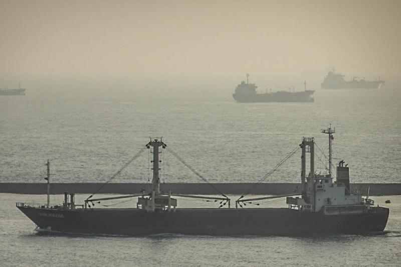
MARIAM M — Cargo

Built in 1997, with a gross tonnage of 4,801 GT, and a dead weight of 6,277 tonnes, MARIAM M is a cargo registered under the United Republic of Tanzania flag. The vessel is owned by XINHAI SHIPPING - WEIHAI, CHINA, built by SANYO SHIPBUILDING - MUKAISHIMA, JAPAN.

MARIAM M route and voyage history

MARIAM M is currently on a voyage from DAMIETTA to ALEXANDRIA ANCH with an estimated arrival on 2026-06-22T14:53:00Z. The live route and current course of MARIAM M are shown on the bridge map above, updated whenever the vessel is in range of a coastal AIS receiver or a satellite pass. View MARIAM M's full route replay to see voyage history, course changes, and port-by-port movement.

Vessel class and identifiers

MARIAM M is classed by NIPPON KAIJI KYOKAI (NKK), which inspects the vessel against its safety and structural rules. Vessels in the same class as MARIAM M can be seen in the Similar Vessels section above or in the full cargo fleet at /vessel-type/cargo.

Frequently Asked Questions

What are the identifiers for MARIAM M?+
MARIAM M broadcasts MMSI 677028200 and is registered as IMO 9167667, with call sign 5IM382. The MMSI is the radio identifier used by AIS; the IMO number stays with the ship for life and does not change with re-flagging or sale.
What type of ship is MARIAM M?+
MARIAM M is classified as a cargo vessel registered under the TZ flag. The vessel-type classification is derived from the AIS Type field broadcast by the ship's transponder; full cargo fleet at /vessel-type/cargo and full TZ flag list at /flag/tz.
How can I see the live position of MARIAM M?+
MarineRadar shows the latest AIS broadcast from MARIAM M above, with current position, course, speed, and navigation status. Tap "View on map" to centre the live tracker on the vessel and watch its movement update in real time. The same data is available offline-friendly in the iOS and Android apps.
How often is MARIAM M's position updated?+
AIS transponders broadcast position every 2 seconds when underway at high speed and up to every 3 minutes at anchor. The position you see refreshes whenever the ship is in range of a coastal AIS receiver or a satellite pass — typically seconds in coastal waters and minutes offshore.
What class is MARIAM M?+
MARIAM M is classed by NIPPON KAIJI KYOKAI (NKK), the classification society responsible for inspecting the vessel against safety, structural and operational rules. As a cargo, MARIAM M sits in the same design class as the other cargos listed in the Similar Vessels section of the vessel page, or in the full cargo directory at /vessel-type/cargo. MARIAM M has a gross tonnage of 4,801 GT.

MARIAM M — Key Facts

MMSI
677028200
IMO number
9167667
Call sign
5IM382
Vessel type
Cargo
Flag state
TZ
Navigation status
At anchor
Current speed
0.1 knots
Course over ground
142.0°
Heading
281°
Last known position
31.2112°, 29.7659°
Destination
ALEXANDRIA ANCH
ETA
2026-06-22T14:53:00Z
Departure port
DAMIETTA
Actual time of departure
2026-06-21T22:20:00Z
Current draught
4.2 m
Maximum static draught
4.5 m
Year built
1997-01-01
Gross tonnage
4801
Dead weight
6277 t
AIS last updated
2026-06-23T12:51:00Z