
Track ATLAS COVE live on MarineRadar
Real-time AIS positions, voyage history, and arrival alerts for ATLAS COVE — straight from your phone.
Similar Vessels
Nearby vessels of the same type
Explore related maritime data
Dive into the fleet, port, and flag state that ATLAS COVE is part of.
About ATLAS COVE
Identity · Ownership · Class · Route
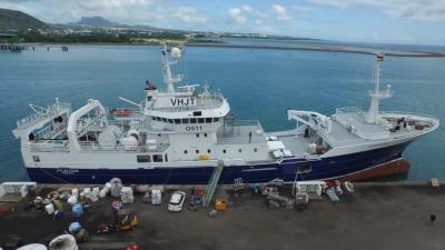
ATLAS COVE — Fishing
Built in 1999, with a gross tonnage of 1,906 GT, and a dead weight of 850 tonnes, ATLAS COVE is a fishing registered under the Antarctica flag. The vessel is owned by OSTERFJORD - TORANGSVAAG, NORWAY, built by KARMSUND MARITIME SERVICES - KOPERVIK, NORWAY.
ATLAS COVE route and voyage history
ATLAS COVE is currently on a voyage from REUNION to REUNION with an estimated arrival on 2026-09-24T07:00:00Z. The live route and current course of ATLAS COVE are shown on the bridge map above, updated whenever the vessel is in range of a coastal AIS receiver or a satellite pass. View ATLAS COVE's full route replay to see voyage history, course changes, and port-by-port movement.
Vessel class and identifiers
Vessels in the same class as ATLAS COVE can be seen in the Similar Vessels section above or in the full fishing fleet at /vessel-type/fishing.
- MMSI:
635019500 - IMO:
9171008 - Call sign:
FMUX - Vessel type: Fishing
- Flag state: Antarctica