Honduras flag

LUCY JCargo · IMO 7810208

HNUnderway Using Engine
World map showing the last known position of LUCY J at 45° 17.092' N, 28° 28.386' E
NSEW

Latitude / Longitude

45° 17.092' N
28° 28.386' E

Show in Map
Updated 47 minutes ago using terrestrial data
Live Satellite · every 5 min

Need more up-to-date positions?

This page shows terrestrial AIS. Download the app for live satellite tracking, refreshed every 5 minutes worldwide.

Get App
Underway Using Engine
Current Navigational Status
10.3 kn
Speed
113.0°
/ 96°
Course / Heading
5.5 m
Static Draught
5.5 m
Current Draught
ATD
Jun 23, 2026, 10:51 UTC
ETA
Jun 23, 2026, 05:27 UTC
From
GALATI
To
BRAILA

Voyage Tracker

Romania flag
GALATIROGAL
ATD
10:51 UTCJun 23, 2026
Romania flag
BRAILAROBRA
ETA
05:27 UTCJun 23, 2026
LUCY J

LUCY J

Identity

Cargo
Type
Honduras flagHN
Flag
7810208
IMO Number
334019000
MMSI
HQAH2
Call Sign

Specifications

107 m × 15 m
Length × Breadth
1979-01-01
Year Built
6,105 t
Deadweight
3,967 t
Gross Tonnage
2,647 kW
Engine Power
STORVIKS MEKANISKE VERKSTED - KRISTIANSUND, NORWAY
Builder
BUREAU VERITAS
Class Society
Live tracking · 50,000+ mariners

Track LUCY J live on MarineRadar

Real-time AIS positions, voyage history, and arrival alerts for LUCY J — straight from your phone.

Live AIS positionsVoyage historyArrival alerts
Get the App

4.6 ★ · 18,000 reviews

Dive into the fleet, port, and flag state that LUCY J is part of.

Flag State
All HN-flagged vessels
Browse every ship currently registered under the HN flag, with live AIS positions.
Vessel Type
Browse all Cargos
See the global fleet of cargos tracked on MarineRadar with live AIS data.
Departure Port
Port of GALATI
Port traffic, arrivals and live vessel positions for GALATI (ROGAL).
Destination Port
Port of BRAILA
Arrivals, berth specifications, and live vessel traffic for BRAILA (ROBRA).

About LUCY J

Identity · Ownership · Class · Route
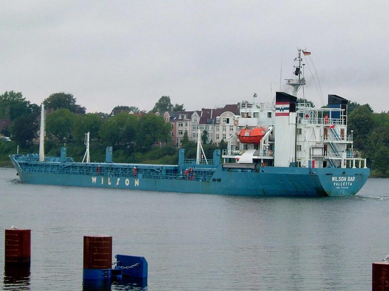
LUCY J — Cargo

Built in 1979, with a gross tonnage of 3,967 GT, and a dead weight of 6,105 tonnes, LUCY J is a cargo registered under the Honduras flag. The vessel is owned by WILSON - BERGEN, NORWAY, built by STORVIKS MEKANISKE VERKSTED - KRISTIANSUND, NORWAY.

LUCY J route and voyage history

LUCY J is currently on a voyage from GALATI to BRAILA with an estimated arrival on 2026-06-23T05:27:00Z. The live route and current course of LUCY J are shown on the bridge map above, updated whenever the vessel is in range of a coastal AIS receiver or a satellite pass. View LUCY J's full route replay to see voyage history, course changes, and port-by-port movement.

Vessel class and identifiers

LUCY J is classed by BUREAU VERITAS, which inspects the vessel against its safety and structural rules. Vessels in the same class as LUCY J can be seen in the Similar Vessels section above or in the full cargo fleet at /vessel-type/cargo.

  • MMSI: 334019000
  • IMO: 7810208
  • Call sign: HQAH2
  • Vessel type: Cargo
  • Flag state: Honduras

Frequently Asked Questions

What are the identifiers for LUCY J?+
LUCY J broadcasts MMSI 334019000 and is registered as IMO 7810208, with call sign HQAH2. The MMSI is the radio identifier used by AIS; the IMO number stays with the ship for life and does not change with re-flagging or sale.
What type of ship is LUCY J?+
LUCY J is classified as a cargo vessel registered under the HN flag. The vessel-type classification is derived from the AIS Type field broadcast by the ship's transponder; full cargo fleet at /vessel-type/cargo and full HN flag list at /flag/hn.
How can I see the live position of LUCY J?+
MarineRadar shows the latest AIS broadcast from LUCY J above, with current position, course, speed, and navigation status. Tap "View on map" to centre the live tracker on the vessel and watch its movement update in real time. The same data is available offline-friendly in the iOS and Android apps.
How often is LUCY J's position updated?+
AIS transponders broadcast position every 2 seconds when underway at high speed and up to every 3 minutes at anchor. The position you see refreshes whenever the ship is in range of a coastal AIS receiver or a satellite pass — typically seconds in coastal waters and minutes offshore.
What class is LUCY J?+
LUCY J is classed by BUREAU VERITAS, the classification society responsible for inspecting the vessel against safety, structural and operational rules. As a cargo, LUCY J sits in the same design class as the other cargos listed in the Similar Vessels section of the vessel page, or in the full cargo directory at /vessel-type/cargo. LUCY J has a gross tonnage of 3,967 GT.

LUCY J — Key Facts

MMSI
334019000
IMO number
7810208
Call sign
HQAH2
Vessel type
Cargo
Flag state
HN
Navigation status
Underway Using Engine
Current speed
10.3 knots
Course over ground
113.0°
Heading
96°
Last known position
45.2849°, 28.4731°
Destination
BRAILA
ETA
2026-06-23T05:27:00Z
Departure port
GALATI
Actual time of departure
2026-06-23T10:51:00Z
Current draught
5.5 m
Maximum static draught
5.5 m
Year built
1979-01-01
Gross tonnage
3967
Dead weight
6105 t
AIS last updated
2026-06-23T12:53:34Z